Xenophilia
In praise of human variety
|
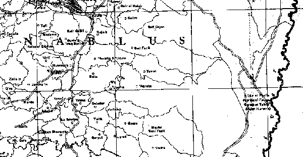
Palestine: honeycomb This is a small fraction of a map (one of my treasured possessions) produced by Sami Hadawi, an official of the British Mandate government of Palestine, from survey maps and taxation records of 1947 or earlier.
It shows the settlement pattern of old Arab Palestine: the towns and thousand villages—and the tribes—and their boundaries, a great net of spidery lines. It is a honeycomb pattern: every village, with its dot and its name, was the nucleus of a cell of land, two or three or four miles wide. Land and villages were organically bound: each cell of land supported its nucleus, the village. Each family farmed several of the fields radiating from the village to the boundary. This was a system like that of a country such as England before the Enclosures, and quite unlike the villages of a country such as modern England, which have loose or no connection with the land around them (most of the inhabitants do not farm, many go to work in distant cities, the surrounding fields belong to a separate farming system). The net of boundaries on the map is dense along the broad hilly backbone of Palestine. But on the eastern fringes it fans out into larger cells, elongating into the "wilderness" that lies in the rain-shadow of the highlands. And these cells do not have dots in them: the names are not villages but tribes—`Arab Ibn `Ubeid, `Arab et Ta`âmira, `Arab er Rashâyida, `Arab el Ka`âbina. This is `arab in its earliest sense of "people of the desert, nomads". Down into the Judean wilderness toward the Jordan valley and the Dead Sea, and down into the southern desert of the Negev, stretch these cells. They are the territories along which people rove by seasonal transhumance—out into the desert as it blooms with fodder after the winter rains, back up to the greener top as the summer drought lengthens. Not showable by the map are the sub-segments of the territories: nomad tribes do not wander capriciously, but divide the tribal corridor of land into lanes corresponding to their lineages. But looking closely, you see that there is a transitional zone: cells of intermediate size, with a village up at the western end, such as Majdal Bani Fâdil, "tower of the children of Fâdil, the Excellent". These are the half-settled tribes, people caught in a stage of change: foraging down into the wilderness in the old way in spring, retreating in summer to a village, at first temporary, at the top. And all this is part of a wider pattern, beyond what the Palestine map alone can show. If it were extended eastward, we would see that the trough of the Jordan valley causes a repetition, a second start. The coastal plain, then the bar of upland, then the rain-shadowed downslope, then the Jordan valley, usable only by irrigation; then, a second bar of highlands catching rain from the west (Transjordan, as it used to be called, now the center of the kingdom of Jordan). And so the pattern is repeated: again the honeycomb of agricultural villages, though perhaps a narrower band of them. Then again, as the highlands slope gradually away eastward, comes the half-sedentarized zone, and then again the territories of the seasonal nomads elongating out into the drier tableland. Then comes a further transformation: the territories elongate vastly into the great desert of Arabia itself! There are two kinds of nomads: the sheep-and-goat nomads near the settled borderland, and the camel nomads of the deep desert, who require much more space and regard themselves as the only true Badw, the great tribes, the kingmakers of the past. The thinly populated desert supplies people to the sown (the "Fertile Crescent"). Groups that are pushed out of the broad world of the camel nomads become sheep-and-goat nomads at civilization's edge; then in a later generation become half-sedentary; then become villagers. It has gone on throughout history; perhaps the invasion of Joshua and the Hebrews, gloriously storming Jericho and Gibeon, was really part of this humbler infiltrating process. And this is the structure of society throughout the Middle East, or the lands east and south of the Mediterranean. In these cultures, the bulk of the population—sixty percent, I think I read—consists of the villagers: the peasant farmers. The minorities on either side of them are the nomads and the city-dwellers; throughout history the proportions have stayed about the same, even as nomads move into the peasantry and peasants move into the cities; perhaps in our time the source finally withers and the shift is inexorably into the cities. The villagers of Palestine simply worked their land because it had always been theirs. Written titles came in under the bureaucratic rule of the Ottomans, who felt a need to ape European ways; wealthy men acquired these titles; land was put up for sale in distant Beirut and sold over the villagers' heads to absentee landlords; as yet it made little difference to the villagers who they had to pay rent to. When the early Zionists came to Palestine, hoping idealistically to transcend the European confinement of Jews to ghettos and moneylending by becoming agriculturists, they bought land from those absentee landlords; but now, instead of letting the tenant villagers who lived there continue to farm it as they always had done, they took it over and founded their own farming colonies. Thus they tore fragments out of the cells that had supported the villages. The ancient honeycomb is half smashed. — The women of each Palestinian village have traditional costumes, rich with embroidery, and often with encrustations of coins and bracelets, and felt headdresses overlaid with silk and draped with shawls. Many are shown in a book called Traditional Palestinian Embroidery and Jewelry, by Abd as-Samih Abu Omar (Jerusalem, 1986). For instance, the thob ghabani dress of Silwan and other villages near Jerusalem has emboidery of silk from Aleppo in a stitch called qutbeh tahrireh; the married women's dress of Beit Jala has embroidered seams called tminjil; Ramallah and Jifna have their White Rumi ("Greek") and Black Rumi dresses of hand-woven linen embroidered with the villages' own motifs; the bridal gown from Lifta is called Janneh wa Nar ("heaven and hell", or more literally "garden and fire") because of its alternating green and red panels; and there were likewise costumes of Sarafand and Beit Dajan (Beth Dagon of the Philistines) and other communities that exist no more.
|