|
Aswan at cusps of earth and sky
Aswan is interesting for its position — its two kinds of position.
It is at a geographical crossing-point between two regions, and
also at an astronomical turning-point between two halves of the
year.
The two regions
are Egypt and Nubia; or, we might say, the Smooth Nile and the Stony
Nile. The Nile makes a slit across the Sahara, a linear oasis across
the world's largest desert. The ancient Egyptians could sail up
the river as far as Aswan, where they were confronted by the First
Cataract. They explored past it; pushed their expeditions on to
the Second Cataract, the Third, and eventually a Sixth, past the
confluence with the Atbara and half way to Khartoum where the Blue
Nile joins the White.
The region of the
cataracts was called Kush by the Egyptians, Ethiopia by the Greeks,
and Nubia after new tribes came into it about 300 AD, until most
of it was absorbed into the modern Sudan. (Aithi-opia and
Sûd-ân have about the same meaning: “burnt-face”
in Greek, “blacks” in Arabic. The Ethiopia name originally
applied to everything south of Egypt.) The political boundary drawn
when the British took over Sudan in 1898 is about 140 miles south
of Aswan, so that a northern strip of the former Nubia now belongs
to Egypt.
Cataract,
from the Greek for “down-rush,” usually means violently
falling water. So when I first read of the Egyptians venturing beyond
the First Cataract I found it an exciting picture: they find the
smooth road of their river barred by a waterfall, they portage up
past it and push on, generation by generation, up a watery stair,
into unknown Africa. But actually the Nile “cataracts”
are not falls, seldom even rapids, and show little white water.
They are stretches where the river is rough because it runs shallow
over rocks and is broken among islands. So the selection of the
Six Cataracts is somewhat arbitrary, and others have sometimes been
named between them.
Geologically, the
region is one that is gently rising, doming. And so the river here
is in a “young” state, cutting down on its bed, like a
mountain stream. By contrast the region still farther up, in southern
Sudan, is “old,” wandering slowly over its own mud in
the bowl of a huge plain, especially in the great marshes called
the Sudd.
Downstream, after
the First or really last of its cataracts, the river resumes its
“old” character. It flows rock-free more than seven hundred
miles to where it spreads into its delta and finds the sea. (In
Egyptian Arabic, the word for “north” is bahri,
“seaward.”)
It is flowing on
a bed of its own making. Every year, after the May rains on the
mountains of Abyssinia, the Flood pulses down the Blue Nile, inundates
Egypt in June, and shrinks back after depositing rich silt. Or did,
until dammed in the twentieth century.
In fact, the Nile
valley from Aswan down, which looks to be a flat-floored valley
just a few hundred feet below the surrounding desert, is a canyon
filled up to that level with silt. The canyon begins at Aswan, gets
deeper as it goes north, till at Cairo it is eight thousand feet
deep! Cairo floats eight thousand feet above the real bottom of
the canyon. What could have cut this canyon but the Nile itself,
flowing to far below sea-level, and how could that be? Because the
Mediterranean was then empty. About six million years ago the Strait
of Gibraltar was squeezed shut, and the Mediterranean evaporated,
becoming a huge depression (far larger and deeper than any of the
present below-sea-level places — the Jordan valley, the Caspian,
Death Valley, the Tarim Basin, Djibouti, or the several depressions
in the Sahara such as Siwa and Qattara in Egypt). It was dry except
for some brackish pools at the bottom, which remain down there as
salt beds. Then about 600,000 years later the world ocean broke
through the strait in a stupendous cascade, far larger than Niagara,
refilling the Mediterrean in a matter of months. The Egyptian canyon
must have become a long inlet, which the Nile set about silting
up. It has filled it with silt all the way back to the Mediterranean
coastline and out farther, forming the delta.
The annual creaming
with silt by the Nile flood was the basis of Egypt's fertility.
It has been stopped by the damming, though in geological time it
will continue: in a few million years, the reservoirs will have
silted, the dams will have broken, the Nile will be flooding as
of old, the delta will build out farther — and then the Strait
of Gibraltar will close again, the Mediterranean will empty, the
Nile will re-cut its canyon, the cycle will repeat.
The town at the
southern end of Egypt was called Swenet,and may have been dedicated
to a goddess of that name, a goddess of childbirth. There are conflicting
ideas that the word had to do with “trade,” “granite,”
or “opening.” The place was like a birth-canal; from here
the Nile's floods opened into Egypt which they had created, child
of the river. In Greek the form was Suênê, spelt in our Latin
transliteration as Syene. In Coptic (descended from ancient Egyptian)
it is Swân; Arabic has to break up initial groups of consonants,
so, Aswân.
And here, where
the Stony Nile ended, was Egypt's best quarry, from which blocks
of Syenite granite were cut and floated down the Nile for use in
temples, statues, and obelisks. The largest of all known obelisks,
137 feet long, cracked before it could be completely cut away, so
there it still lies along the slope above Aswan — the Unfinished
Obelisk.
Being half way across
the Sahara from north to south, Aswan is Egypt's hottest and one
of the world's driest inhabited places. A bit of rain fell one day
in 1994, and the next was one day in 2006. Nubians often did not
bother to put roofs on their houses. Since the Nile after entering
the desert has no tributaries, and no rainfall, and much evaporation,
and much water withdrawn from it by irrigation, it must get smaller
in volume all the way to the sea.
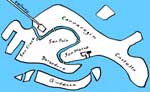
At the northern
end of the First Cataract is an island, three-quarters of a mile
long, called Elephantine. It lies beside Aswan, and may have been
where the city started. It bore a fort guarding Egypt's southern
end, temples, and two of the earliest “nilometers” —
rock-cut surfaces on which the levels of the floodwater were marked.
And farther south,
two of the small islands in the “cataract” were called
Philae, seeming to mean in Greek the “beloved” ones (feminine
plural), but adapted from an Egyptian name Pilak. The smaller islet,
four hundred yards long, was the sacred one, crammed with temples
— more than thirty of them by Roman times.
The Nile floods
were sometimes too much and sometimes too little, and the idea that
they should be controlled occurred to Al-Hakîm, a ruler of Egypt
so strange and austere that the later Druze religion was founded
on worship of him. In 1011 AD he summoned from Iraq the scientist
Ibn al-Haytham, called in Europe Alhazen, who believed he could
solve any problem. Alhazen studied the possibility of building a
dam at the First Cataract, found it beyond him, feigned madness
to avoid the caliph's wrath, and was put under house arrest for
ten years, during which he wrote his major work (on optics).
What is now called
the Aswan Old Dam or Low Dam was built by the British between 1898
and 1902. It is about five miles upstream from Aswan, so that the
part of the “cataract” from there down to Aswan survives
as a band of channels and islands, some of them now a nature reserve
into which you can take a boat trip. The masonry dam was, at the
time, the largest that had ever been attempted. It had a lock at
its west side, enabling ships to get past and sail on up to the
Second Cataract, and sluices allowing the silty floodwaters to pass
through. When the sluices were closed the lake behind filled, covering
most of the islands in the upper part of the “cataract.”
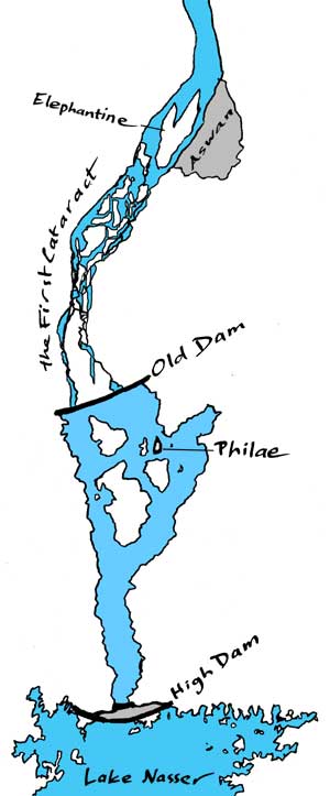 So for the next half century the sacred
isle of Philae was, most of the time, drowned. It became, in a way,
an even more beautiful sight, with boats sailing among the temples'
pylons and columns, and the surviving colors of the paint on the
reliefs reflected in the water, which however was rotting them away.
So for the next half century the sacred
isle of Philae was, most of the time, drowned. It became, in a way,
an even more beautiful sight, with boats sailing among the temples'
pylons and columns, and the surviving colors of the paint on the
reliefs reflected in the water, which however was rotting them away.
The dam did not
sufficiently control the floods and had to be raised twice. The
British thought of building a second dam, another four miles upstream,
but this was left to the regime of Nasser, which in the 1950s received
funding, technicians, and equipment from the Soviet Union. Construction
of this High Dam began in 1960, took ten years, and by 1976 “Lake
Nasser” was filled. It stretches more than three hundred miles
south, with a fantastically complicated coastline of islands and
inlets probing among the wrinkles of the desert. The lake reaches
across the boundary into Sudan, which prefers to call it “Lake
Nubia.” Egypt gained controllable water and electricity, but
there were environmental consequences. In place of the renewed silt,
farmers have to use fertilizers. Even more Nile water is evaporated,
from the vast lake. Salt water invades the Delta. Hundreds of thousands
of Nubian people were displaced (including the Sudanese city Wadi
Halfa), many of them being moved to “Nasser City” near
Aswan. Because of the High Dam, the Low Dam's sluices and lock lost
their functions of passing floodwater down and shipping up the river.
Many more archaeological
remains were doomed to go underwater. An international effort led
by UNESCO raised many of the prettiest — the temples — most
notably Abu Simbel, carved into a cliff far south along the western
side of the river. The engineering feat was immense: cutting an
underground monument into blocks, lifting it and putting it back
together on the plateau above, and building over it a hill to simulate
the cliff. And it was now also that in the smaller lake between
the two dams, the opportunity was taken to salvage Philae. It was
first surrounded with a coffer dam, and then almost all its temples
— in 40,000 pieces whose positions had been carefully recorded
— were moved half a kilometer westward to a higher isle, called
Agilkia, which was itself cut to the original Philae's shape.
Aswân is now Egypt's
third largest city, after Cairo where the valley and the Delta meet,
and Alexandria at the coast. The length of Egypt from Alexandria
to Aswan is about 525 miles, but is said to be more like 700 along
the river.
The second distinction of Aswan is that it is on the Tropic of Cancer. Or close: the latitude of Aswan is 24º 5' north; of the tropic, 23º 26', so the tropic lies forty miles or so farther south, astride Lake Nasser. The Tropic of Cancer is the line around the earth along which the midday sun, on the day when it is farthest north (the June solstice, on or about June 21), passes exactly overhead.
This was known in ancient times. At midsummer noon, the walls of the Philae temples went black as shadows fell straight down them, an eerie contrast with the glare of earth and sky. And the noon sun shone straight down a deep well on the island Elephantine; as could be seen because the brilliant reflection was complete on the water at the bottom. Or as close as the eye could discern.
Eratosthenes heard about this and realized that from it he could calculate the size of the earth.
Eratosthenes (about 276 to 195 BC), from Cyrene in Libya, was one of the many scholars gathered at Alexandria in the times of the first few Ptolemies, the Greek kings of Egypt. Alexandria then was not only capital of Egypt but the largest city in the world (the world known to the Greeks that is), a center of intellectual life; Eratosthenes became head of its great library, which was essentially a university.
What he realized was that if the earth is a sphere (which it was known to be because of its circular shadow when eclipsing the moon), and if Alexandria is due north of Syene, and if the sun is at a virtually infinite distance, and if it is vertically overhead at Syene, and at the same moment is a certain angle from overhead at Alexandria, then that angle is a fraction of the circle of 360º, and the distance along the ground is the same fraction of the total distance around the earth. So he needed just two figures, the angle and the distance.
He measured the angle of the solstice midday sunlight at Alexandria by measuring the shadow cast by a vertical pole. As for the distance from Alexandria to Syene, he is said to have estimated it merely from the time taken to travel it by camel, but I like the story that relays of walkers were employed to measure distances, with chains between their ankles to equalize their strides.
The angle was 7.2º, which is a 50th of 360º. The distance was 5,040 stadia. So the circumference of the earth was that multiplied by 50: 252,000 stadia. A stadion was the length of a furrow or of a racetrack, but what was that? It varied at Greek places and times from 172 to 230 yards, so there is debate as to which stadion Eratosthenes used. Assuming the smallest, and a median of 200 yards, and the largest, the circumference of the earth was about 24,600 miles, or 28,600, or 33,000. It is now known to be 24,900 miles.
Not bad, considering that Alexandria is not quite due north of Aswan (it is 3º farther west); and the sun, as Eratosthenes knew, is not at infinite distance, so its rays are not precisely parallel; and it is not precisely vertical at Aswan; and the distance from Alexandria is not easy to measure — the road and the river are not straight lines. But more nearly so than in most countries. Linear Egypt, from Alexandria to Aswan, a fiftieth of the world circle, was a more convenient measuring-stick than Eratosthenes could have found anywhere else.
|