|
Hundred-Gated Thebes
The Greeks knew of a third Thebes in a third continent, larger than their own Seven-Gated city, a far-off place so awesome that they called it the Hundred-Gated — and they knew of it as early as Homer. In the Iliad, Achilles exclaims (Book IX, 381-2) that his anger, that viciously disproportionate anger of his, will not be assuaged by gifts from Agamemnon, even if they were to include all the wealth “that goes into Orchomenus” (a proverbially rich city that was the neighbor and rival of Greek Thebes) “or into Thêbas Aiguptias, Egyptian Thebes, in whose houses the greatest treasures are laid up, which is hekatompuloi, having a hundred gates, from each of which two hundred men go forth with horses and chariots.”
By this Thebes the Greeks meant a city that had been Egypt's capital in its most glorious time, about the time of the heroic age which was remembered in their own legends. Thêbai may have been their rendering of Ta-Opet, later Ta-Pe, apparently a designation of the city's largest temple; another Egyptian name may have been pronounced something like Niyût ’Amân, the city of the god Amon, mentioned in the Hebrew Bible as Nô' ’Amôn. The Greeks identified Amon with their own chief god, and so another name was Diospolis, “Zeus's city” (yes, Dios is the genitive form of Zeus).
Thebes (Ta-Opet, No Amon, Diospolis, Thebes Hecatompyli . . . ) is more than four hundred miles up the Nile, just past a large bend that takes the river nearer to the Red Sea coast. It was a provincial town until, a thousand years after the beginning of Egypt's history, it rose to be capital because its local rulers won a struggle with another city (Heracleopolis) to become pharaohs of the united country. They formed the 11th Dynasty (about 2130 to 1990 BC). (These “dynasties” are the divisions made by Manetho, an Egyptian priest writing a history in Greek about 250 BC.) The first pharaoh of the 12th Dynasty, though a Theban, moved the capital downriver. Then came two centuries of weakness and fragmentation, which scholars call the Second Intermediate Period (about 1770-1550), when the Hyksos “shepherd kings,” Semitic people from Asia, infiltrated northeastern Egypt and dominated the rest. Then another line of Thebans, forming the 17th Dynasty, began a struggle to drive the Hyksos out; when this succeeded, the 17th Dynasty became the 18th (the last king of the one, Kamose, was brother of the first king of the next, Ahmose). Thus began, with Thebes as capital, the age called the New Kingdom, the height of Egypt's civilization and power.
The 18th Dynasty (about 1550 to 1290) was contemporary with other interesting phases of the Late Bronze Age — the Minoan and Mycenaean civilizations in Crete and Greece, the wanderings of the Hebrew patriarchs — and was itself a time ornamented by good stories. It included not only the series of conquering Amonhoteps and Thutmoses but:
—Hatshepsut, the strong woman who held down the most aggressive of those warlords. (Her name: hat, “foremost”; sheps, “noble”; -u, plural ending; -t, feminine ending — “foremost of noble females.”) She was daughter and heir of Thutmose I; husband and co-regent of his son (her half-brother) Thutmose II; then after this second Thutmose's death she was supposed to be merely guardian of his son (her nephew and stepson) Thutmose III. But for 22 years she dominated this third Thutmose, making herself full “king” (she wore the symbolic false beard), and fostering trade and peace. At her death he destroyed all traces of her that he could and launched endless war into Asia.
—Amonhotep IV, who changed his name to Akhenaten when he instituted the heretic religion of one god, Aten the beneficent sun-disk. And he encouraged a new naturalistic style of art (which showed his own elongated chin and womanish body); and moved the capital for a few years (about 1346 to 1335) far downriver to a city that he built on a virgin site and called Akhetaten, “horizon of Aten.” The site is now called Amarna, and at it was discovered the trove of Amarna Letters — nearly four hundred clay tablets bearing detailed correspondence with colonial officials in Palestine and Syria and the kings of Babylon, Assyria, Mitanni, and the Hittites.
—Tutankhaten, Akhenaten's nine-year-old heir. In his short reign the polytheistic priesthood of the Theban god Amon swept back to power, so that the boy changed his name to Tutankhamon, the experimental city was abandoned and the capital moved back to Thebes. Sickly, dead at eighteen, Tutankhamon was laid in a small but rich tomb that, hidden under others, chanced to be the only one untouched — almost — by tomb-robbers until Howard Carter discovered it in 1922.
(It might be interesting to mention, in case you wonder why we fail to write Amenhotpe, Tuthmosis, Ikhnaton, Tutankhamun, or whatever your favorite spellings are, that Egyptians wrote only the consonants, so that the vowels with which we make them pronounceable are conventions, partly based on Manetho's Greek distortions of late Egyptian. Thothmes or Tuthmosis or Thutmose or Tehuti-mes was “born of” a god whose name may have sounded like Djehûty; and linguists think that “King Tut” may have spoken his name as something like Tawât ‘Ânakh ’Amân, “image of the eternal life of Amon.”)
Thebes continued as capital during the 19th Dynasty (about 1300 to 1187), which, at first, maintained the Nubia-to-Syria empire of the 18th; and during most of the 20th (1187 to 1085). Then came pharaohs who were based at Tanis in the delta and had lost control of Upper Egypt.
Thebes had a stark structure. It was divided into the city of the
living, on the right or east bank of the Nile, and the city of the
dead, on the west, the country of the sunset.
(Actually, this
part of the Nile valley aims closer to northeast than to north;
and the reach of the river slanting past Thebes points about twenty
degrees east of north. But even this, as we'll see, lent itself
to an extra piece of symbolism.)
 The
city that now sprawls for about four miles along the east bank is
called Luxor; the northern part of it, once a separate village,
is called Karnak. The
city that now sprawls for about four miles along the east bank is
called Luxor; the northern part of it, once a separate village,
is called Karnak.
The whole place
has become an enormous tourist magnet. The ministry of tourism planned
on a rise to 11 million visitors per year to the Karnak temple;
came the January 2011 revolution, and for a while you could have
it to yourself and only a few hundred others. As a fourteen-year-old
I drank in Egyptology and longed to find my way some day to those
far-off dusty sites where Champollion had deciphered hieroglyphs
and Flinders Petrie had pieced together the systems of weights used
in ancient markets. Now at Gatwick airport you are marshalled into
long lines for the planes to Alicante or Dubai or — Luxor! “Luxor”
sounds like the most golden of holiday paradises; people on their
way to bask in the deck pools of Nile cruise ships and to be guided
around vast photographable ruins no doubt associate the name with
luxury.
But it has nothing
to do with Latin luxus; it is Arabic, al-Uqsur. This
is the plural form of qasr, which means “castle”
or “palace.” Explanation: the Arabic language has a luxuriant
system of these “broken plurals”; some words are made
plural by adding an ending, as we do in English (castle-s), but
more often plurals are made by playing with the vowels around the
three consonants of which most words are made. Thus malik,
“king,” mulûk, “kings”; kalb,
“dog,” kilâb, “dogs”; walad, “boy,”
awlâd, “boys”; nahr, “river,”
anhur, “rivers”; ’amîr, “commander,”
’umarâ', “commanders”; qandîl, “lamp,”
qanâdîl, “lamps”; and many other patterns. For
qasr I have seen the plurals qusûr, aqsûr, uqsur.
And the word itself
is surely a borrowing from Latin castra, “camp,”
which is the origin of our “castle” and the names of places
like Chester and Manchester and Exeter.
And what were these
“castles” that the Arabs wondered at when they overran
Egypt in 640 AD? They were the huge temples of two and three thousand
years before, half buried in sand.
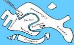
The Karnak temple,
or complex of temples, is Egypt's largest. There were small temples
on the site in the 11th Dynasty; additions were made under most
of the pharaohs of the 18th and 19th dynasties, then desultorily
down to the beginning of Greek rule in Egypt. The major element
is a row of great structures running away from the river, eastward.
(Actually, east-south-eastward, because of the river's local direction.)
This axis included a canal (only recently discovered) leading from
the river to a harbor; a vast forecourt; an avenue of sphinxes;
several massive pylons, that is, double gatehouses of the characteristic
slope-sided Egyptian kind; a hypostyle hall of 134 enormous columns,
of which the central 16, even higher, make a nave; obelisks, one
of which, Hatshepsut's, her successor Thutmose hid by surrounding
it with a wall. How men raised these monsters of stone is a subject
of continuing debate and experiment. Perhaps the pylons were the
multiple “gates” the Greeks had heard of.
At a right-angle
to this main axis, another row of structures runs south (really
south-south-west), passing by a sacred lake, and including courts,
pylons, and sub-temples. All of the above are surrounded by a square
wall, enclosing 55 acres, the Precinct of Amon-Re, who was a fusion
of the Theban god with Re or Ra the national sun-god. Outside, the
north-south axis is extended on the north by the smaller precinct
of Montu (another god associated with Thebes), and on the south
by that of Mut. Beyond Mut this river-paralleling axis is continued
by a line of sphinxes, recently uncovered through the midst of the
town, toward the temple of Luxor, another whole great complex, dedicated
to the Theban Triad: Amon, his wife Mut, and their son Khonsu. On
top of one of its parts stands a mosque, built up there when the
ancient temples were deep in sand.
Thus Luxor-Karnak, the city of the living, surrounding the great
temples between which went the annual procession. Across the river,
the Necropolis or city of the dead. This also consists of two parts:
the mortuary temples along the western edge of the valley, and the
tombs beyond that edge.
The god-king's body
lay forever in his tomb, while his soul went on to pass its tests
into the afterworld. But in addition to the tomb he needed a mortuary
temple, built like the tomb in his lifetime, for the rites of his
mummification and for a priesthood to continue his cult. Back in
the Old and Middle Kingdoms, kings had been buried in brick or stone
mounds (mastabas), from which developed pyramids. These were in
the north of Egypt but all to the west of the Nile, up on the plateau
that was the beginning of the desert; and mortuary temples began
to be built up there close to them. Perhaps because the huge above-ground
tombs were such conspicuous targets for robbers, they were succeeded
in the New Kingdom by artificial caves, tunnels of extraordinary
length and elaboration.
The Nile valley
is a ribbon of flat alluvial ground with the river swinging in curves
along it, and we tend to think of it as bounded on each side by
a cliff line which is the front of the desert plateau. It is like
that in some parts, but from the air you can see that most areas
of the desert near to the valley are dissected into a maze of wrinkled
gullies — which is to be expected, as flash floods, after the
rare thunder showers, erode their way to the lower level through
ground undefended by vegetation. This is especially true of the
district of highland, called the Theban Hills, enclosed on three
sides by the large bend in the valley. One of these systems of dry
gullies, coming out opposite to Karnak, winds leftward as you go
up into it, so that its head is not far back inside the cliffs.
It is a hidden valley, behind the cliff front. (And one of the peaks
overlooking it, cut out by gullies, looks like a pyramid.) This
is the Valley of the Kings, where from the early 18th Dynasty down
to the end of the 20th more than sixty kings, queens, and lucky
nobles were richly buried. The tunnel-tombs had sometimes more than
a hundred chambers; as with temples, the space became smaller toward
the inner and most sacred end; the long passages were not blocked
up with stone but with doors, whose guards were corruptible, so
that the riches were always eventually plundered by men desperate
enough to risk horrible punishment.
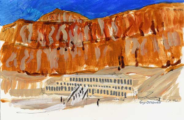
Of the mortuary
temples along the valley's edge, the most spectacular is that of
Hatshepsut. The slope leading up to it, now dry, was her garden,
where she planted myrrh trees brought back by an expedition she
had sent to the land of Punt (perhaps Somalia). The temple rises
in three terraces, fronted by wide colonnades. It is one of the
world's most beautiful buildings, but lost to the world until the
nineteenth century. (At one time monks lived among the ruins, hence
the name of the site, Deir el-Bahri, “the northern monastery.”)
The temple is against the foot of a high semicircular golden cliff
that seems to tower so nearly vertical behind it that you fear rocks
will drop onto the roof.
If
you could soar upward, you would see that this cliff is razor-topped;
it drops as steeply on the other side — into the Valley of the
Kings! And high in the nearest branch of the valley is Hatshepsut's
tomb. The tomb was actually the first in the valley, cut for Hatshepsut's
father Thutmose I, then shared by her. The tomb has a plan unlike
any other: it starts eastward but (always descending) bends progressively
to the right, almost in a semicircle. It may be that Hatshepsut's
intention, prevented by encountering unsound rock, was to drive
her tomb through like a tunnel to the rock-cut chamber at the back
of her temple.
Go back to the great
Karnak temple and look along its axis. It points over the river
and across two miles of almost flat ground to Hatshepsut and the
cliff behind her.
Or, equivalently,
stand on the steps of Hatshepsut's temple before dawn at the midwinter
solstice. The axis of this temple points back to Karnak and, beyond
it, the rising sun: the rising-point of the sun that is farthest
south along the horizon.
In other words,
the two temples are constructed along one line, and this line, running
west-north-west to east-south-east, happens to be the direction
to the winter-solstice sunrise.
Not exactly. I figure
that the axis through the Karnak temple points about 26 degrees
south of east; that through Hatshepsut's temple, 22 degrees south
of east; each of them passes slightly north of the other. And on
December 22 or thereabouts, the azimuth of sunrise at this latitude
is only 11 degrees south of east.
Obviously the Karnak
axis is intended to be at right-angles to the river, and a river
isn't a perfect line, so there is no need for precision here. It
is well believable that Hatshepsut chose for her temple the cliff
bay pointed at by the Karnak temple's axis, it being the most magnificent
site anyway. (It had already been used by a pharaoh of five centuries
earlier, Mentuhotep II of the 11th Dynasty, whose temple lies, less
well placed and less brilliantly designed, alongside hers.) It is
also believable that she laid out her temple and its forecourts
to point back — near enough, given the shape of the ground —
to the great temple across the river. And the orientation toward
the midwinter sunrise? That it was a lucky accident, and that it
was 11 or 15 degrees off, doesn't mean that the Egyptians did not
intend or appreciate it. And, after all, the sun, revealing itself
from behind the eastern hills and climbing at a slope (of about
40 degrees at this time), is at the right azimuth a few minutes
after rising.
As with many of
the other astronomical orientations found by scholars, such as in
the Pyramids and in Abu Simbel, and in Mayan temples and Stonehenge,
I suspect that the precision is a concern of moderns with their
drawing tools and calculators, rather than of the ancients.
|