|
Istanbul and the City of the Blind
You may have opened an atlas and noticed a remarkable piece of
geography: something that looks like a river, snaking through a
block of land between two seas. The river is in two parts, called
the Bosporus and the Dardanelles (or Hellespont), with a miniature
sea called Marmara connecting them.
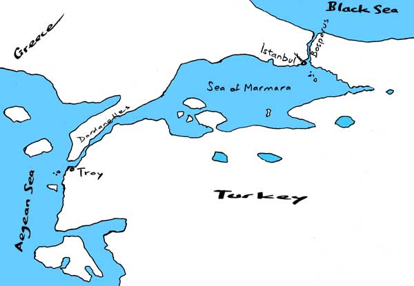 This triple waterway
marks for us the juncture between Europe and Asia. And it is indeed
a kind of river, flowing westward, from the Black Sea into the Aegean.
That is, the top level of the water flows that way; there is a smaller
under-current back the other way. During the last ice age, when
the seas were lower, there was no water connection through here
and the Black Sea was a lake in a depression, like the Caspian.
When sea level rose, the “river” made its way through,
and some archaeologists think it first broke through the Bosporus
as a tremendous cascade, accounting for the legend of the Flood.
This triple waterway
marks for us the juncture between Europe and Asia. And it is indeed
a kind of river, flowing westward, from the Black Sea into the Aegean.
That is, the top level of the water flows that way; there is a smaller
under-current back the other way. During the last ice age, when
the seas were lower, there was no water connection through here
and the Black Sea was a lake in a depression, like the Caspian.
When sea level rose, the “river” made its way through,
and some archaeologists think it first broke through the Bosporus
as a tremendous cascade, accounting for the legend of the Flood.
Along these straits
go commerce from one sea to the other, and across them commerce
and migrations from one continent to the other, so it is no wonder
that forts and towns were founded along their banks to control them.
Troy was one of the most ancient, at the mouth of the Dardanelles.
The Bosporus offers even better control, being less than two miles
wide (less than half a mile in some parts). In 685 BC, colonists
from Megara in Greece founded Chalcedon, on the eastern corner of
the mouth where the Bosporus enters the Sea of Marmara. Yet they
could easily have seen that the opposite corner would have been
a better choice, because it had a fine sheltered harbor, opening
right next to it into the Bosporus: a three-mile-long estuary, which
we call the Golden Horn.
The Megarians could
have lost that chance to some other of the ambitious Greek cities,
but they were lucky: seventeen years later, when they were ready
to send out another colony, the Delphic oracle told them, using
the cryptic language of oracles, to build “opposite to the
blind.” “The blind”! — they saw what it meant:
Chalcedon. So they settled, under their King Byzas, on the western
corner, which became Byzantium. Chalcedon soon came under the rule
of Byzantium, and was mocked long afterwards as “the city of
the blind.”
 “Constantinople
is a very long name; how do you spell it?” runs the schoolboy
joke, the answer being “I T.” The name may not be the
longest of all placenames (that distinction is claimed for Llanfairpwllgwyngyllgogerychwyrndrobwllllantysiliogogococh
on the Welsh island of Anglesey or Taumatawhakatangihangakoauauotamateaturipukakapikimaungahoronukupokaiwhenuakitanatahu
in New Zealand), but the city may be the one that has had the most
names. To tell its names is to tell its history.
“Constantinople
is a very long name; how do you spell it?” runs the schoolboy
joke, the answer being “I T.” The name may not be the
longest of all placenames (that distinction is claimed for Llanfairpwllgwyngyllgogerychwyrndrobwllllantysiliogogococh
on the Welsh island of Anglesey or Taumatawhakatangihangakoauauotamateaturipukakapikimaungahoronukupokaiwhenuakitanatahu
in New Zealand), but the city may be the one that has had the most
names. To tell its names is to tell its history.
Before Byzantium,
there had been Lygos, a settlement of the indigenous Thracian tribes.
In 330 AD Constantine, the first Roman emperor to convert to Christianity,
chose Byzantium as the new capital of the empire, calling it Nova
Roma (Latin) or Nea Rhoma (Greek), “new Rome.” (Constantine
did not impose Christianity, but imposed toleration of it. And he
did not divide the empire into its western and eastern halves; that
had been done by Diocletian just before him, and he reunited it;
the division happened again in 395 and became permanent.) Later
the city became known as Kônstantinoupolis, “Constantine's
city.” After the collapse of Rome itself in 476, the eastern
empire became the only Roman empire. Though calling itself that,
or just Romania, it was Greek in language and culture; and people
often called the great capital just hê polis, “the city,”
and talked of going “into the city,” eis tên polin.
For a thousand years the Byzantine empire lasted, undergoing times
of expansion (from Spain to Armenia) and times when it shriveled;
lost its heartland in Asia Minor to the Seljuk Turks in 1071; the
city was looted by other Christians — Crusaders from the west
— and had to be abandoned for sixty years; the empire recovered,
but feebly; became surrounded by the Ottoman Turks, to whom at last
it fell in 1453. From eis tên polin came the Turkish form
Istanbul. The modern Turkish alphabet writes this with a dot over
the I, because there are two i vowels in Turkish and this
is the bright front one. Europeans turned Kônstantinoupolis into
Constantinople and Istanbul into Stamboul.
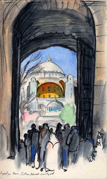
Constantinople's
great church has also been a name- and function-changer: Hagia Sophia
(“holy wisdom”), in Latin Sancta Sophia or Sancta Sapientia,
in Italian Santa Sofia, in Turkish Ayasofya. The “wisdom”
to which it was dedicated was the Logos, the Word, which according
to the Gospel of John became incarnated in Christ. It was built
around 530 under Justinian at the height of Byzantine power, and
it was the largest of all cathedrals till surpassed by Seville in
1520. In form it is a hemispherical dome supported by four semicircular
arches, two of which are the fronts of half-domes, below which are
smaller half-domes, and there are vaulted spaces around — a
cluster of domes, making a symmetrical mountain of stone.
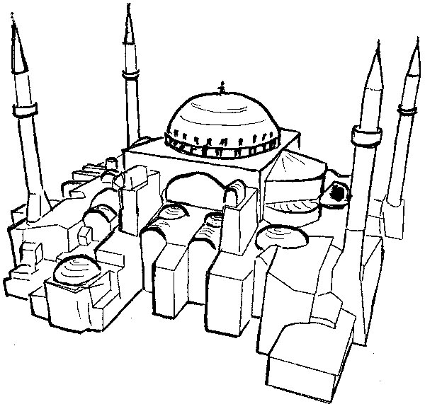
The Turks
converted it to a mosque and set at its corners four minarets, like
tall pencils. In the 1930s it passed from mosque into museum.
It was the inspiration
for the masterpieces of Turkish architecture: many mosques resembling
it were built in the late 1500s by Sinan (who was a Muslim of Greek
origin) in Istanbul and also at Edirne, deeper into Europe; and
around 1600 Sultan Ahmed's mosque, called the Blue Mosque, arose
on the former site of the Byzantine palace, facing across a garden
to Hagia Sophia.
The first time I passed through Istanbul and crossed by ferry from
Europe to Asia, I looked around and thought of the scene as a magnified
village pond, around which stood the multitude of minarets.
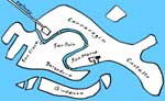
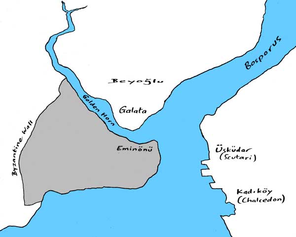
The promontory between
sea and harbor remains the city's nucleus. It is called Saray Burnu,
the headland of the seraglio, and on it, surrounded by gardens,
is the TopkapI, the “gun gate” palace; a little farther
back, the great mosques. The city of Byzantine times spread about
four miles back to where its wall, four miles long, curved from
Golden Horn to Marmara — the enormous wall that failed to keep
out the Crusaders and the Turks. And in later ages the city spread
and spread, becoming a cluster of cities on both sides of the Golden
Horn and on both sides of the Bosporus. It embraces Chalcedon (now
Kadiköy) and Scutari (Üsküdar) and other places in Asia across the
Bosporus, and Galata across the Golden Horn and other satellites
on the European side. It is not so much a city as a built region,
stretching twenty miles or so into Europe, almost as far up the
Bosporus, and twice as far along the Asian shore. This region is
shaped the way it is by a web of geological faults. And much of
the hasty growth is in box-like frames of concrete filled in with
skins of brick, which collapsed in the earthqueke of 1999 (the day
after I left), killing 17,000. Yet the slender minarets stood.
|